Article by Richard Kirton
Sunday 23 December 2018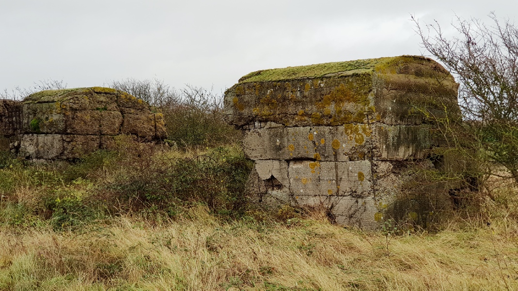
A section of the Mock-up Atlantic Wall on Foulness Island
The real Atlantic Wall was a coastal defensive structure built on Hitler’s orders that stretched from Norway, along the Belgium and French coastline to the Spanish border. The wall covered a distance of 1,670 miles and was built between 1942 and 1944 with the purpose of fending off an attack on Nazi-occupied Europe by the UK. The wall formed the main part of Hitler’s ‘Fortress Europe’ and was one of the most impressive engineering feats of the day.
Hitler issued the order to build this wall on March 23, 1942 in his now famous ‘Directive 40’. The plan called for the construction of 15,000 separate concrete emplacements to be manned by 300,000 soldiers. The wall absorbed a huge amount of German resources and more than 260,000 workers were used to build it, using over 17 million cubic metres of concrete and 1.2 million tons of steel.
However, British, American and Canadian troops breached the seemingly impregnable Nazi defences along an 80-mile stretch of the French coastline at Normandy in a single day, the 6th June 1944. This would not have been possible without the co-operation of the French Resistance. British Military Intelligence had asked them to secure valuable information including aerial photographs and documents about the German Atlantic Wall, which showed its size, structure and materials that it was made of.
In order to achieve a successful seaborne invasion into occupied France, the Allied Forces knew that they would have to break through these German defences. A great deal of effort was therefore put into developing the technology to achieve this, including specialised tanks – known as “Hobart’s Funnies” which were developed by Major-General Percy Hobart. This enabled accurate mock-ups of the Atlantic Wall to be built in various locations in the UK. These were used for military training and testing prior to D-Day in June 1944.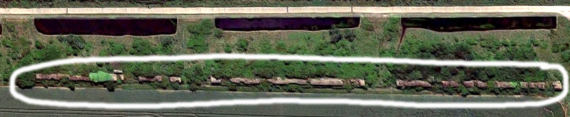
The Mock-up Atlantic Wall on Foulness Island
[Left-click the picture to see short video clip of the 1200 feet long wall]
Not many people that I have spoken to were aware of the existence of this local mock-up wall which is approximately 1210 feet in length, but Phillip Mobbs, a young man from Bristol is in the process of researching all five of the UK locations. He found National Archive documents showing that such a site was constructed on Foulness island and Roger Burroughs confirmed that this particular mock-up Atlantic Wall actually flanks a small section of his farmland on the east coast, south of Fisherman’s Head. Phil made a four-hour trip from Bristol to meet up with Roger and myself to confirm legitimacy of the wall’s existence. The wall can clearly be seen approaching Fisherman’s Head from the public footpath along the Riverbank which runs adjacent to ‘The Broomway’.
After the war, the French felt embarrassed by the abandoned defences and decided to start demolishing them as soon as possible, but this was taking a long time. However, many years later, the public began to preserve sections of the Atlantic Wall and some of the fortifications still stand today, drawing thousands of tourists annually. In Holland and Denmark also, the remains of the 'Atlantic Wall' defences are being used to lure tourists.
Phillip Mobbs’ own website is a ‘work in progress’ and well worth investigating further:
Normandy War Guide
He has created a dedicated page for those who wish to visit Normandy called:
Planning your trip to Normandy
Other excellent websites worth visiting include:
The Atlantic Wall in Normandy
The Atlantic Wall [The History Learning Site]
The Atlantic Wall [Pillbox Study Group]
Military History Now [11 Amazing Facts About the Nazi Defences at Normandy]