Little Wak ering
ering
According to 'White's Directory of Essex 1848' WAKERING (LITTLE) is a village and Parish, on the north side of Great Wakering, 4½ East by South of Rochford, at the head of a navigable creek, which communicates with the sea, Broomhill river, and the islands of Potton, Havengore, etc. In the island creeks are extensive oyster layings; and in Maplin Sands, off the coast, are mussel and winkle grounds, belonging to the two Wakerings, and adjacent parishes. Little Wakering contains 301 inhabitants, and 2721 acres of land, including the small islands of Little Potton and New Eng1and. The manor of Little Wakering was generally held by the same families as Great Wakering, and Sir J. T. Tyrell, Bart., is its present lord, but a great part of the soil belongs to other proprietors.
The Church (Virgin Mary,) is a small antique building, with a nave, chancel, and tower. On the latter are the arms of Bishop Wakering, and those of France, England, and Bohan. The was appropriated at an early period to St. Bartholomew's Hospital, London, and the governors of that institution are still impropriators of the rectory and patrons or the vicarage; valued in K.B. at £12, and in 1831 at £190. The Rev. Joseph E. Commins. M.A. of North Shoebury, is the incumbent; and Thomas Clough Taylor, Esq., is lessee of the great tithes. The Poor's Land comprises about 2A., called the Play-stall, and has been vested with the parish officers from an early period, but the donor is unknown.
Great Wake ring
ring
According to 'White's Directory of Essex 1848' WAKERING (GREAT) is a large village, pleasantly situated on rising ground above the marshes. One mile from the sea shore, 5 miles East South East of Rochford, and 4½ miles East North East of Southend. Its parish contains 860 souls, and 2755 acres of land, including the small Islands of Great Potton and Rushley, together with the other islands clustered in the eastern angle of this Hundred. The lands round the village rise above the islands and marshes bordering on the sea and the creek, and the whole parish has a rich soil, in a high state of cultivation. The subsoil is clay, and at the depth of three feet is a white sand, and under it, in some places, is a reddish gravel. The lordship was held by Suene, at the Norman Conquest, and after being forfeited by Henry de Essex, it passed to the noble family of Nevill.
In 1421, it became the portion of Anne, Countess of Stafford, and by her third husband it passed to the Bourchiers. Sir J.T. Tirell, Bart., of Boreham, is now lord of the of manor but Barrow Hall, Adam's Fee, Lovetots, and other estates, belongs to other proprietors. Barrow Hall farm is mostly in Little Wakering. The Wakerings, who took their name from the parish, were seated here in the 15th and 16th centuries, at Barrow Hall, and a branch of them at Wakering Place. Adam's Fee belonged to Adam Fitz-Simon, and is vulgarly called Aldermans. Lovetots estate extends into Little Wakering, and is supposed to have been held by the ancient family of Lovetot.
Foulness I sland
sland
There are no records to say when Foulness became an island. Research by AWE (Foulness) Archaeological Society suggests that Foulness was occupied for a short period circa 180-280 AD. Foulness is the largest of a group of 6 islands in the Thames estuary, including Potton, Rushley, Havengore, New England & Wallasea. The Sea Wall was probably constructed in the 12th Century. It was recorded that in 1049 in the reign of Edward the Confessor, several vessels landed there. Population increased rapidly with the arrival of arable farming. In 1424 Foulness had 57 fish weirs, 18 Kiddells (V shaped nets) and 10 long lines. In 1801 the population of Foulness was 396.
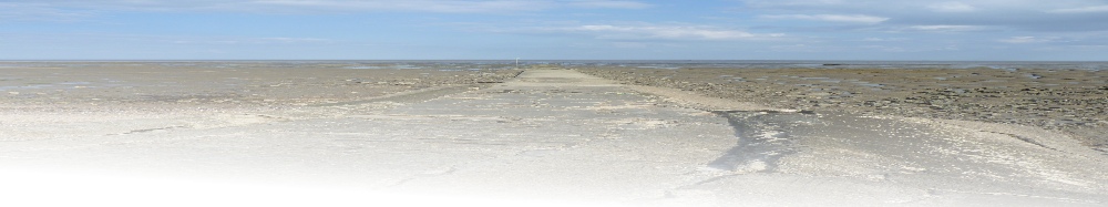
By 1871 it had risen to 754. The coastline of Foulness has sunk several feet over the last 2000 years. An off shore track known as the Broomway has been known since ancient times and links Great Wakering with Foulness Island. This track runs parallel to the coast and about half a mile from it over the mudflats. In 1953 when floods struck the area, Foulness Island was cut off for 2 days and the Broomway was once again a lifeline.
History of the Villages and Islands
Barling
According to 'White's Directory of Essex 1848' BARLING is a small village and parish, on a creek of the river Broomhill, opposite Potton Island, 4 miles East of Rochford, and contains 1260 acres of land and 326 inhabitants. It is a peculiar of the Dean and Chapter of St. Paul's, who are lords of the manor, patrons of the church, and appropriators of the rectory. The manor was given to St. Paul's Cathedral by Edward the Confessor; and in 1253, the Dean purchased the low marsh land on the east side of the parish. In 1322, the Dean agreed with Adam de Barling and his tenants for the erection of an embankment to keep the tidal waters out of this marsh, and in consideration thereof, be gave to Adam and his heirs the profits of the fishery in the creek for ever.
Mucking Hall estate belongs to Lady Sparrow, and other parts of the parish belong to Robert Adcock, W.S. Jones, Thomas Rogers, Charles Wiseman, and several residents. The Church (All Saints,) is an ancient structure, with tower, spire, and four bells. The benefice is a vicarage, valued in K.B. at £18, and in 1831 at £308, and now enjoyed by the Rev. J.T. Bennett, M.A., of London, one of the minor canons of St. Paul's. The tithes were commuted in 1843. The Poor's Cottage, near the churchyard, was given at an early period by an unknown donor, and is occupied rent free by a poor family.
New Engla nd Island
Flooded in 1897 and 1953. Belonged to Little Wakering parish. It was the area’s principal breeding grounds for sheep. During the 16th century it was in part-ownership of Lord Rich. The Ministry of Defence took over in 1915. No one lives on New England Island today.
Havengore Island
In 'White's Directory of Essex 1848' Havengore Island is stated as being at the southern angle of the cluster of islands, is of an oval figure, bounded by the sea and the creeks communicating with the river Broomhill. It has only 18 inhabitants, and about 810 acres of land, all extra-parochial, except Sharpness Farm, and a small portion of laud, called Temple Marsh, which are in Little Wakering parish. It is the property of Lady Sparrow, and Mr. James Tabor is the only resident farmer. The new bridge links Havengore Island to New England and Foulness Islands. The name is derived from ‘haven’ (for fishermen) and ‘gor’, which is Old English for the ever-present mud. The old parish of Havengore was known in the 13th century as Havenemersche.
The creeks around Havengore are now used for leisure time yachtsmen but in the nineteenth century, fleets of barges transported bricks from Wakering brickfields to London and brought back London’s rubbish to be burned in the kilns. The barges moored at Mill Head, and carried up to 45,000 bricks at a time. There were two farms on the island in the 1860s. It was an unhealthy place where agues, fevers and consumption were typical. The local gypsy woman (Mrs Print) made money selling "cures". Havengore became that the property of various significant local landowners including Lady Olivia Sparrow (Lady of the Manor at Leigh on Sea) and James Tabor (Lord of the Manor of Rochford). There was a great deal of smuggling around the maze of creeks. In 1857 as part of an anti-smuggling effort, two old naval hulks were stationed as river blockages. One of these was allegedly the ‘Beagle’, the ship on which naturalist Charles Darwin made his evolutionary voyage.
Potton Isla nd
nd
Today it is the subject of Ministry of Defence restrictions on access, and there is little to see there. The island is 2 miles long and 1 mile wide, and is the most westerly of the five islands in the Essex Archipelago – 1 mile north of Great Wakering. Access is through Great Wakering Common. The Potton name comes from a personal name ‘Pott(a)’. Other names referring to it are ‘Pottyng(e)’ or ‘Pottyngore’ (1419) and ‘Pottingwick’ (1612). There are also other references from the 13th century. Evidence of occupation of Potton Island dates back to Neolithic, Bronze Age, and Roman times. Farming was extensive on Potton in the 19th century, with "sheets of golden corn", with wildlife in the form of rabbits, hares, partridges, widgeon, mallard, teal, pochard, and shelduck.
One landowner introduced unusual farming experiments including cultivating black grass to feed to the ducks on the ‘gentleman’s’ pond, damming water furrows to preserve water for the dry summers, and fattening hogs on mustard seed to give flavour to the pork.In 1884, Potton was flooded. The flood destroyed crops and animals and the land was used only for pasture for many years afterwards. It was described in the 1920s as "a great treeless prairie". In the 1940s the land was re-claimed and crops reintroduced by Harold Philpott. The livestock included the 350 cattle, 200 sheep and at least 1000 pigs.During World War II, 250 bombs fell on Potton Island and it had its own Home Guard. In order to improve access, compacted oyster and mussel shell roads were laid to enable farm wagons to cross. In the 1953 floods 11 people were trapped on the island but all were rescued safely. In 1955 the Ministry of Defence took over although 80% of the land was leased back for farming. Since reverted to pasture.
Rushley Is land
land
In 1781 John Harriott began to enclose the whole island with three miles of seawall. A farm and several wells were constructed. The 200 acre island cost Harriott £40 pounds to buy. In 1791 the island was flooded. Harriott abandoned his ambitions and debts and emigrated to America. The island provided evidence of Roman occupation. The name of Russhleye was first recorded in 1576. In the 1930s, pregnant cows from Rushley were often taken to Home Farm in Great Wakering to give birth.
Local racehorse trainer and one-time Rushley owner, Frank Threadgold, once bred a horse named after the island. Not very successful at racing, the horse was retired for breeding by the Threadgold families, who have farmed land at Great Wakering since the 1930s.


© 2015 - Richard Kirton - All Rights Reserved | Privacy Policy | Terms of Use | Site Map