The Village
Extract from ‘The Rayner Family of Great Wakering” by Albert Rayner Bsc (Econ) FCA [page 48]
The size and extent of the village in the latter half of the 19th century can be obtained from a study of the large scale survey maps of that period. There are also available the ten yearly censuses from 1841 to 1881, which also give an indication of the size of population, its occupations and the size of each family.
The village proper consisted of a one mile-long street, High Street or Great Wakering Street as it was called in the earlier censuses. The High Street stretched from St Nicholas Church in the east to 'The Exhibition' public house in the west. The first development last century was on St John's land, off the Shoebury road; these were smal1 brick built cottages and the area was known as Newtown.
St Nicholas Church dates back to 1100AD and was named after the patron saint of sea-farers. It is only 18 feet above sea level and yet commands a good view of the creeks and islands. The church just escaped the serious 1953 floods, which reached to within 100 feet of the church. Great Wakering Common was flooded and 40 homes suffered, with some loss of life.
Apart from a stretch of orchard or market garden opposite the vicarage, and 'Brown the Smith', the south side of the High Street was a continuous row of cottages and shops, built mostly of timber. Some of the many timber buildings are still surviving. There were no continuous roads going to the south but a track crossed Lions Field to Crouchmans and there was Leeks Alley next to the post office.
Adjacent to 'The Exhibition' public house there was a short street named Exhibition Lane, or Brick Lane, which led to the early brick-field which no longer exists.
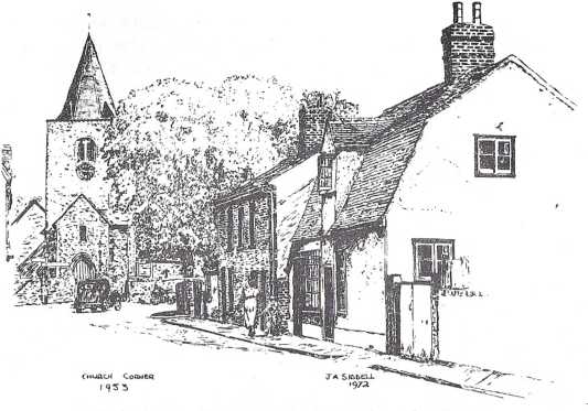
Church Corner, Great Wakering in 1953, by J A Siddell
All the public houses were on the south side of the village, 'The Anchor', 'The Red Lion', 'The White Hart Inn', 'The Bell Inn' and finally 'The Exhibition'.
The north side of the High Street was built up as far as the new school which was opened in 1876. Before reaching the new school was Dog Kennel Lane, which led to the Congregational Church. Beyond the new school were a few scattered cottages and one or two farm houses with their plots of land to the rear. The vicarage was at the corner of Vicarage Lane.
The village was, more or less, self-supporting. There was a considerable number of shops, all in the High Street, and providing reasonable competition. The 1881 Census did, in fact, distinguish between shops and dwellings, and it would seem that along the High Street at least one in five was a shop. As a result of the increasing availability of easy transport in recent years, many of the shops have now closed.
The various censuses include names of buildings, which may be of interest. They are mostly in the High Street and many have since disappeared. 'Owl Hall' or 'Old Hall' has given way to a block of flats and shops, there also being a branch of the County Library on this site. Three houses in Foulness Road (or New Road) at the corner of Shoebury Road, referred to as the 'Old Barracks' were used to house the Wakering Volunteers, under the command of Captain Asplin of Little Wakering Hall. The unit was formed to defend Wakering and Barling at the time of the threatened Napoleonic invasion. There was, in fact, an Asplins Lane near the vicarage, which led to Little Wakering Hall, although it is now referred to as Vicarage Lane.
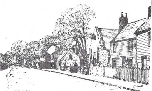
High Street and the Peculiar People's Chapel in 1900, by J A Siddell
The 1881 Census includes 'Pond Row' with six families. These houses are now demolished. They were situated near Brickfield Yard Lane and named after a large pond which was opposite, on the north side of the High Street - but since filled in. There was also 'Holly Cottage' with two families, next to what is now 'The Exhibition' car park. It was John Burgess' bakery and the house has recently been restored for occupation by John's great-grandson, Philip Burgess. Finally, there were three wooden cottages listed as the 'Town Hall', opposite the Methodist Church, and occupied by the Wiggins family. These too have been demolished.
Along most of the length of the South Side of the High Street was the Lion Field, often referred to as the 'Hundred Acres'. Beyond the Methodist Church were three narrow strips of land of two or three acres each and similar strips were on the north side. These were probably, at one time, individual smallholding tofts attached to their respective cottages.
There were, of course, no public services laid to the village. Water, sewerage and electricity were not installed until the early 1930s; gas a little earlier. Some cottages were fortunate in having wells but the rest had to use the standpipes which were at regular intervals along the High Street.
In some of the larger farmhouses, where the occupants had the benefit of a well, a water tank would be installed at the top of the house and it would be the first duty of the domestic servant each morning to pump water to fill the tank ready for use in baths, toilets, etc. So far as lighting was concerned, some of the villagers would be shrewd enough to install a two gallon paraffin tank on the chimney stack. The paraffin would be fed down through narrow piping and used to light the shop or house.
Some houses were covered in ivy. This gave villagers the opportunity of netting at night sparrows and other birds sheltering in the ivy - a useful food for the winter months.
Wakering was in the South Essex Parliamentary Constituency. There was an election in 1880 and public meetings were held at Rochford and Southend. Such meetings were not always peaceful; red ochre, blue ochre and rotten eggs were thrown at the Liberal meeting in the Public Hall in Southend. A Liberal meeting was held in Great Wakering at the 'White Hart' public house - Mr E.A. Wedd was in the chair. Apparently it was well attended, as the Parlour was full and some were in the passage and others outside the windows. Polling Day was 3 April and in Great Wakering the polling was conducted at the Board School - it is even recorded as being quite a jolly event. The result was declared on 5 April:
Baring (Conservative) 4841
Makin (Conservative) 4729
Buxton (Liberal) 4324
Lyall (Liberal) 4147
The Annual Horse, Flower and Sports Show was an important event each August Bank Holiday. Teams from Farms from a wide area would compete. There was great rivalry for the best turn out of Waggons, Carts and Plough Horses. There were sports for the children and games of skill for the adults. 'Catch the greasy pig' caused considerable excitement, but would not be all owed today. A pig, 10 to 12 weeks ol d was covered with cart grease and let loose in the ring. Whoever caught and held the pig would take possession. Another favourite was 'Tilting the Bucket*. A pair would compete, one in a wheelbarrow holding a pole who would be pushed by his mate under a suspended wooden bucket full of water. The object was to push the pole through a ring under the bucket, but almost invariably one or both competitors got drenched. Then there were the cart horse races, young lads galloping on horseback round the ring several times.


© 2015 - Richard Kirton - All Rights Reserved | Privacy Policy | Terms of Use | Site Map