
Introduction
Extract from ‘The Rayner Family of Great Wakering” by Albert Rayner Bsc (Econ) FCA [page 46]
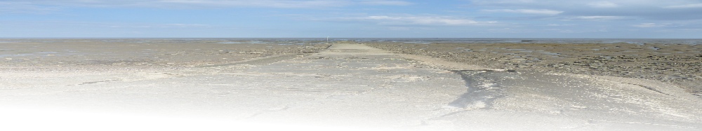
Wakering lies a few miles inland, east of Southend-on-Sea and north of the garrison town of Shoeburyness. Less than a mile away to the east, Havengore Creek and Rushley Reach divide the mainland from the smaller islands, viz Havengore, Rushley, Potton and New England, which are sometimes referred to as the 'Essex Archipelago'. Beyond is Foulness Island, which is Government property and has been considered as an alternative site for an additional airport for London. The Creek is tidal and sea walls run along the length of the coast of both the mainland and the islands. At low tide it is possible to walk along the 'Broomway', an ancient track which crosses the Maplin Sands from Wakering Stairs on the mainland to Fisherman's Head on Foulness - six miles in length and a quarter of a mile from the shore. The trackway is marked by bunches of poles and twigs or 'withies' as they are known locally. There have been tragic deaths along the Broomway. In 1805 Thomas Miller, a surgeon from Wakering, was overtaken by the tide and drowned, and in 1836, two girls named Chittock and Bates attempted to cross the sands from Foulness to the mainland, to meet their sweethearts who were waiting at Wakering for them. The girls lost their way in the fog - which can be very thick off Foulness - and were drowned.
North east of the village is Great Wakering Common, with scattered cottages. Beyond the Common were important brickfields, of which there is now practically no trace. North west of the village is the smaller village of Little Wakering, now almost linked to Great Wakering by houses. A short distance beyond is the hamlet of Barling, almost surrounded by creeks and saltings.
The discovery of axe heads and relics of the Bronze Age provides evidence of settlements in this area as far back as 2000BC. Wakering was also an important place for the Romans, being so near the Thames Estuary. There was a Roman road leading to Wakering, which branched off at Billericay from the Roman road to Colchester. The creeks and islands provided excellent access for infiltration by the Anglo-Saxons who entered Britain after the departure of the Romans. Many of the archaeological finds from this area were collected by Philip Benton, the historian, and passed by him to the Southend Museum although a few of the more important ones are now at the British Museum - one is, in fact, on loan to the Tower of London. It is interesting to note that one of the finds in the recent Viking excavations at York is a strap-end, similar in design to a find in Wakering. Both Barling and Wakering are listed in the Domesday Book of 1086, under the names of Berlinga and Wachelinga; the name Wakering derives from the Saxon 'Wake' or 'Watchers'. The old English name was Waceringas (Waker's people). The following is an extract from the Domesday Book, suitably amended:
'Wachelinga is held by Suen in demesne as 51/2 hides (area). Before and after 1086 2 villeins and 18 borders (a border was a villein of the lowest rank who rendered service for a cottage held at the will of his lord) and 2 ploughs were on the demesne and a third could be employed. There is woodland for 40 swine, pasture for 300 sheep. There was an average of 3 rounceys (riding horses), 112 sheep, 32 swine and 5 beast (probably oxen). Suen also held Little Wakering and Prittlewell.'
Apart from the brickworks still in operation to the south west of the village, the surrounding country is agricultural, with scattered farm houses It is mainly arable together with dairy herds and sheep on the marshes.


© 2015 - Richard Kirton - All Rights Reserved | Privacy Policy | Terms of Use | Site Map